
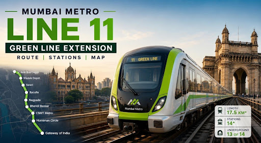
Mumbai Metro Line 11: Green Line Extension Route, Stations, Map
-
By Ayush Oswal
- July 29, 2026
Introduction
Mumbai’s Metro network is gradually reaching parts of the city that have traditionally depended heavily on local trains, BEST buses, taxis and road transport. One of the most important upcoming corridors in this expansion is Mumbai Metro Line 11, commonly associated with the Green Line extension.
The project has changed considerably from its original plan. Metro Line 11 was earlier proposed largely as a Wadala–CSMT extension of Metro Line 4, but the revised corridor now stretches from the Anik/Wadala side towards the Gateway of India, passing through several densely populated parts of Central and South Mumbai. A further extension towards Dharavi and Bandra Terminus was announced in the Maharashtra Budget 2026–27.
This makes the line important not only for areas such as Wadala, Sewri, Byculla and CSMT but also for Nagpada, Bhendi Bazaar, Fort and the Gateway of India precinct. Once the proposed Bandra extension is taken forward, its reach could become even wider.
Here is a closer look at the Mumbai Metro Line 11 route, stations, map, project cost, completion timeline and latest status.
Also Read:- Pros and Cons of Buying a Property Near Mumbai Metro Lines
Quick Answer
Mumbai Metro Line 11 is an extension of Mumbai’s Green Line network. The currently planned main corridor runs for roughly 17.5 km between Anik Bus Depot and Gateway of India, with 14 stations, of which 13 are proposed underground and Anik Bus Depot is at grade.
The Maharashtra government has also announced a further 6.9 km extension towards Bandra Terminus through Chunabhatti, Sion and Dharavi, adding five proposed stations. The base Anik Depot–Gateway corridor is targeted for completion around August 2032 under the present JICA implementation schedule.
Mumbai Metro Line 11 Project Snapshot
| Particular | Details |
| Metro Line | Mumbai Metro Line 11 |
| Network | Green Line extension |
| Main Approved/Planned Corridor | Anik Bus Depot to Gateway of India |
| Approximate Length | 17.5 km |
| Main Corridor Stations | 14 |
| Underground Stations | 13 |
| At-grade Station | Anik Bus Depot |
| Implementing Agency | Mumbai Metro Rail Corporation Limited |
| Estimated Base Project Cost | ₹23,487 crore |
| Maximum Design Speed | 90 kmph |
| Maximum Operating Speed | 80 kmph |
| Base Project Completion Target | August 2032 |
| Proposed Additional Extension | Towards Bandra Terminus via Dharavi |
| Proposed Extension Length | About 6.9 km |
| Proposed Additional Stations | 5 |
| Current Stage | Planning, surveys, consultancy and pre-construction activities |
The EIA documents give the preferred Anik Depot–Gateway alignment at about 17.51 km, while the Ministry of Housing and Urban Affairs has referred to it as approximately 17.41 km. Such small differences are common while alignments and detailed project measurements are being finalised.
Also Read:- How Much Should I Earn to Buy a House in Mumbai?
What is Mumbai Metro Line 11?
Mumbai Metro Line 11 is being developed as an extension of the wider Green Line system.
The Green Line network broadly includes Metro Lines 4, 4A and their planned extensions. Metro Line 4 itself connects Wadala with Kasarvadavali through the eastern suburbs and Thane, while Line 4A continues from Kasarvadavali towards Gaimukh.
Metro Line 11 takes this connectivity further towards Mumbai city.
This is what makes the project particularly important. Instead of ending the Green Line around Wadala, the wider network can eventually connect commuters from Thane and the eastern side of the metropolitan region with Central and South Mumbai.
Mumbai Metro Line 11 Route
The revised Mumbai Metro Line 11 route begins around Anik Bus Depot, moves through the Wadala and port-side areas and then turns towards some of Mumbai’s busiest older neighbourhoods.
It will cover Wadala, Sewri, Byculla, Nagpada and Bhendi Bazaar before reaching CSMT, Fort and finally the Gateway of India area.
The preferred alignment is:
Anik Bus Depot → Wadala Depot → CGS Colony → Ganesh Nagar → BPT Hospital → Sewri → Hay Bunder → Darukhana → Byculla → Nagpada Junction → Bhendi Bazaar → CSMT Metro → Horniman Circle → Gateway of India.
This is considerably different from the older Line 11 alignment shown in some earlier Mumbai Metro maps.
Also Read:- Mumbai Metro Line 3 Map: Route Map | Opening Date | Latest News
Mumbai Metro Line 11 Stations
The revised main corridor has 14 proposed stations.
| No. | Metro Line 11 Station | Proposed Type |
| 1 | Anik Bus Depot | At Grade |
| 2 | Wadala Depot | Underground |
| 3 | CGS Colony | Underground |
| 4 | Ganesh Nagar | Underground |
| 5 | BPT Hospital | Underground |
| 6 | Sewri | Underground |
| 7 | Hay Bunder | Underground |
| 8 | Darukhana | Underground |
| 9 | Byculla | Underground |
| 10 | Nagpada Junction | Underground |
| 11 | Bhendi Bazaar | Underground |
| 12 | CSMT Metro | Underground |
| 13 | Horniman Circle | Underground |
| 14 | Gateway of India | Underground |
The station names should still be treated as proposed names until the final construction and operational naming process is completed.
Also Read:- Mumbai Metro Line 5: Route Map | Stations List | Opening Date | Today Status
Mumbai Metro Line 11 Map
The revised Mumbai Metro Line 11 map is quite different from the original Green Line extension.
The earlier alignment generally moved from Wadala towards CSMT through the eastern waterfront. Under the revised plan, the line bends inland after the port areas so that it can serve Byculla, Nagpada and Bhendi Bazaar before reaching CSMT and continuing towards Fort and the Gateway of India.
The official project map shows the corridor moving south from Anik and Wadala through Sewri, then towards Byculla and Nagpada before continuing to CSMT, Horniman Circle and Gateway of India.
In simplified form, the map can be understood as:
Anik/Wadala → Sewri → Byculla → Nagpada → Bhendi Bazaar → CSMT → Fort → Gateway of India
The alignment is especially significant because many of these neighbourhoods currently do not have direct Metro access.
Why Was the Mumbai Metro Line 11 Route Changed?
The original Line 11 plan was considerably shorter.
MMRDA’s older Metro master-plan documents identified Line 11 largely as a Wadala–CSMT corridor of about 12.7 km.
The revised alignment increased the reach of the project towards the Gateway of India and shifted the route through neighbourhoods such as Byculla, Nagpada and Bhendi Bazaar.
This provides a wider catchment area and brings Metro connectivity closer to densely populated residential, commercial and heritage areas of Central and South Mumbai. The Ministry of Housing and Urban Affairs has specifically identified Wadala, Byculla, Nagpada, Crawford Market/CSMT, Horniman Circle and Gateway of India among the important areas served by the project.
Also Read:- What Are the Upcoming Metro-Connected Projects in Mumbai?
Is Mumbai Metro Line 11 Underground?
Almost the entire main Metro Line 11 corridor will be underground.
According to the preferred alignment studied by MMRC, approximately 16.39 km of the 17.51 km corridor is underground. Anik Bus Depot is proposed as an at-grade station while the remaining stations are planned underground.
An underground design is particularly important on this corridor because it passes through some of Mumbai’s oldest, busiest and most built-up neighbourhoods.
Constructing a long elevated corridor through places such as Byculla, Nagpada, Bhendi Bazaar, CSMT and Fort would involve considerable physical and traffic constraints.
Mumbai Metro Line 11 Bandra Terminus Extension
Metro Line 11 became even more interesting in 2026.
During the Maharashtra Budget 2026–27, the state government announced that the corridor would be extended towards Dharavi and Bandra Terminus. The proposed additional stretch is around 6.9 km.
Five additional stations have been reported for this extension:
| Proposed Extension Station |
| Chunabhatti |
| Sion |
| Central Dharavi |
| Bandra West |
| Bandra Terminus |
Once added to the present corridor, the total network would have around 19 stations, although the exact final length, configuration, project cost and station arrangement of the extension remain subject to detailed planning and approvals.
Also Read:- MHADA&Bandra and Worli Colonies Get Green Light for Redevelopment
Why is the Bandra Extension Important?
Bandra Terminus is an important long-distance railway terminal, but direct Metro access to the terminal has remained limited.
The proposed extension would bring Line 11 through Sion and Dharavi towards Bandra. It would therefore change Line 11 from primarily a north-south South Mumbai corridor into a much broader cross-city connection.
Dharavi is also particularly important because it could create connectivity with other parts of Mumbai’s growing Metro network.
The result could eventually be a corridor connecting Bandra and Dharavi with Wadala, Sewri, Byculla, CSMT, Fort and Gateway of India without relying entirely on the conventional suburban railway system.
Metro Line 11 Connection with Metro Line 4
One of Line 11’s biggest advantages is that it forms part of the wider Green Line system.
Metro Line 4 is being developed between Wadala and Kasarvadavali, while Metro Line 4A continues towards Gaimukh. MMRDA has described Line 11 as the southern extension of this network.
This means a much larger section of the Mumbai Metropolitan Region could eventually benefit from interconnected Metro travel.
The broader Green Line system therefore has relevance not just for Mumbai city but also for Thane and surrounding areas.
Also read:- What Are the New Developing Areas in Mumbai?
Metro Line 11 Interchange at CSMT
CSMT is expected to become one of the most important points on the corridor.
Line 11 proposes a CSMT Metro station, bringing passengers close to the city’s major suburban and long-distance railway terminus.
It is also expected to strengthen connectivity with Mumbai’s wider underground Metro network.
For commuters travelling between eastern Mumbai, Central Mumbai and South Mumbai, CSMT could therefore develop into an important multimodal transport hub.
Metro Line 11 and Gateway of India
Extending the Metro to the Gateway of India area is another major change from the old plan.
The last station of the preferred main alignment is proposed near the Gateway of India/SPM Circle area, after Horniman Circle.
This would improve public transport access to one of Mumbai’s busiest heritage and tourism districts.
It would also provide better Metro access to parts of Fort, Colaba and the commercial areas surrounding the southern end of the city.
Also Read:- Which Is the Most Luxurious Apartment in Mumbai?
Mumbai Metro Line 11 Project Cost
The currently approved base project has an estimated cost of approximately ₹23,487 crore.
The Japan International Cooperation Agency signed an ODA loan agreement in March 2026 for up to 92.4 billion Japanese yen for the Mumbai Metro Line 11 Project.
The announced Bandra extension may require changes to the overall cost because the ₹23,487 crore estimate relates primarily to the Anik/Wadala–Gateway corridor.
Therefore, buyers and investors looking at infrastructure reports should not assume that ₹23,487 crore is necessarily the final cost of the entire eventual Gateway–Bandra network.
Mumbai Metro Line 11 Completion Date
The JICA project implementation schedule gives August 2032 as the planned completion period for the Line 11 project covered under its funding programme.
However, this should not automatically be treated as the confirmed opening date for the entire extended corridor up to Bandra Terminus.
The Bandra extension was announced later and remains at an earlier planning and pre-construction stage. Its construction programme may therefore develop separately.
Also Read:- Cheapest and Affordable Real Estate Regions in Mumbai 2026
Latest Status of Mumbai Metro Line 11 in 2026
As of 2026, Metro Line 11 is moving through important planning and pre-construction stages.
The JICA loan agreement was signed in March 2026, providing a major funding push to the project. JICA’s implementation schedule anticipated consultancy activities during 2026 and the initial underground civil-work procurement process thereafter.
Preparatory work has also begun for the Bandra-side extension, including underground utility surveys along the proposed alignment.
This means the project has moved beyond being simply a line on Mumbai’s long-term Metro map, although substantial construction work and several implementation stages still remain.
How Metro Line 11 Could Affect Connectivity in Mumbai
Metro Line 11 fills an important gap in Mumbai’s Metro planning.
Local trains already provide strong north-south connectivity, but several neighbourhoods between railway corridors remain dependent on buses, taxis, private vehicles and walking for last-mile travel.
Areas such as Nagpada and Bhendi Bazaar are good examples.
By connecting these areas directly with Wadala and CSMT, the corridor could give commuters another option without forcing every journey through the existing suburban railway system.
The Bandra extension could make this effect even stronger by adding an east-west component through Dharavi.
Also Read:- Which Is the Best Residential Building in Mumbai? Top Luxury Projects Worth Exploring in 2026
Possible Real Estate Impact of Mumbai Metro Line 11
Large transport projects can influence real estate, but the effect is rarely identical across every locality.
Wadala already has a large residential development market, while Sewri is receiving attention because of wider infrastructure development around the eastern side of Mumbai. Byculla and parts of Central Mumbai have also witnessed redevelopment and premium residential construction.
Metro Line 11 can strengthen accessibility in these locations.
However, buyers should not purchase a property purely on the assumption that a proposed Metro station will automatically cause prices to rise. Station location, walking distance, neighbourhood development, road access, possession timeline and the stage of Metro construction all matter.
Why Choose Housiey?
Infrastructure can make a property more attractive, but buyers need to look beyond a proposed Metro line on a brochure.
Housiey helps homebuyers compare projects by looking at factors such as actual location, connectivity, developer background, pricing, available inventory and surrounding infrastructure. This makes it easier to understand whether a project genuinely benefits from an upcoming infrastructure corridor or is simply being marketed around it.
For a project close to Mumbai Metro Line 11, buyers should also check the exact proposed station location and practical road distance instead of relying only on statements such as “near upcoming Metro”.
Conclusion
Mumbai Metro Line 11 has developed into a much more ambitious project than the original Wadala–CSMT extension.
The main proposed corridor now links the Anik and Wadala side of Mumbai with Sewri, Byculla, Nagpada, Bhendi Bazaar, CSMT, Horniman Circle and Gateway of India. Most of the route will run underground, which is important considering the density and age of the neighbourhoods it passes through.
The proposed extension towards Sion, Dharavi and Bandra Terminus could further change the role of this corridor in Mumbai’s transport network.
For now, however, it is useful to separate the 17.5 km Anik Depot–Gateway project, which has reached a more advanced approval and funding stage, from the newer Bandra extension whose detailed alignment and implementation are still developing.
Key Takeaways
| Particular | Key Takeaway |
| Mumbai Metro Line 11 | Part of Mumbai’s Green Line network |
| Main Route | Anik Bus Depot to Gateway of India |
| Main Corridor Length | Around 17.5 km |
| Stations | 14 on the main corridor |
| Underground Section | Almost the entire route |
| Major Areas | Wadala, Sewri, Byculla, Nagpada, Bhendi Bazaar, CSMT, Fort |
| Last Main-Corridor Station | Gateway of India |
| Base Project Cost | Around ₹23,487 crore |
| Funding | Includes JICA ODA financing |
| Completion Target | August 2032 for the JICA-funded base project |
| Proposed Extension | Towards Bandra Terminus through Dharavi |
| New Extension Stations | Chunabhatti, Sion, Central Dharavi, Bandra West and Bandra Terminus |
| 2026 Status | Planning, surveys, consultancy and procurement-related activity underway |
Sources
- Mumbai Metropolitan Region Development Authority (MMRDA)
Mumbai Metro master plan, Metro Detailed Project Report information and Line 4, Line 4A and Line 11 corridor details. - Mumbai Metro Rail Corporation Limited (MMRC)
Environmental Impact Assessment and project documents for Mumbai Metro Line 11, including route alignment, station locations and technical specifications. - Ministry of Housing and Urban Affairs, Government of India
Official information regarding the Mumbai Metro Line 11 corridor, major areas covered and its role within Mumbai’s expanding Metro network. - Japan International Cooperation Agency (JICA)
Mumbai Metro Line 11 financing, ODA loan details, implementation schedule and proposed completion timeline. - Government of Maharashtra – Budget 2026–27
Information regarding the proposed extension of Mumbai Metro Line 11 towards Dharavi and Bandra Terminus.
FAQs
Mumbai Metro Line 11 is a proposed Metro corridor forming part of Mumbai’s wider Green Line network. It will connect the Anik/Wadala side of the city with Central and South Mumbai.
The main corridor runs from Anik Bus Depot towards Wadala, Sewri, Byculla, Nagpada, Bhendi Bazaar, CSMT and Gateway of India. A further extension towards Dharavi and Bandra Terminus has also been announced.
The main Anik Depot–Gateway of India corridor is approximately 17.5 km long. A proposed 6.9 km Bandra Terminus extension would make the overall network longer.
The main project has 14 proposed stations. The Bandra extension is expected to add another five stations.
Most of Mumbai Metro Line 11 is proposed to be underground. Anik Bus Depot is planned at grade while the remaining main-corridor stations are underground.
Yes, Line 11 is generally treated as an extension of Mumbai’s Green Line network. It extends the connectivity offered by Metro Line 4 towards Mumbai city and South Mumbai.
The confirmed main project extends towards the Gateway of India area. A further extension towards Bandra Terminus has also been proposed.
Yes, CSMT Metro is one of the proposed stations on the revised Line 11 alignment. It will improve access to one of Mumbai’s most important railway hubs.
Yes, the revised main alignment extends up to the Gateway of India area. The preceding station is proposed at Horniman Circle.
The Maharashtra government announced an extension towards Bandra Terminus in the 2026–27 Budget. The extension is still at an earlier planning and preparatory stage than the main corridor.
The proposed stations include Chunabhatti, Sion, Central Dharavi, Bandra West and Bandra Terminus. Final station names and locations can still change during detailed planning.
The approved base corridor has an estimated project cost of around ₹23,487 crore. The final cost after including the proposed Bandra extension may be different.
The project is being implemented by Mumbai Metro Rail Corporation Limited. The organisation is also responsible for Mumbai’s major underground Metro infrastructure.
The JICA implementation schedule targets completion of the base project by August 2032. The final operational date will depend on construction, approvals, testing and commissioning.
The project is currently going through surveys, consultancy, procurement and other pre-construction activities. Full-scale construction across the entire corridor is not yet complete or operational.
Yes, improving connectivity between Wadala and South Mumbai is one of the main purposes of Line 11. The corridor continues through Central Mumbai before reaching CSMT, Fort and Gateway of India.
Yes, Byculla is included as a proposed underground station on the revised alignment. This will provide another rail-based transport option for the locality.
Yes, Bhendi Bazaar is proposed as an underground station. It is one of the important additions made under the revised alignment.
Improved Metro connectivity can increase the attractiveness of residential and commercial areas near stations over time. Actual property-price movement will still depend on location, supply, demand, redevelopment and the stage of infrastructure completion.
The alignment can be checked through Mumbai Metro planning and project documents released by MMRDA and MMRC. Buyers should rely on the latest official alignment because older maps may still show the discontinued Wadala–CSMT route.

Ayush Oswal is an SEO Executive at Housiey, specializing in optimizing real estate content for better visibility and engagement. With a strong understanding of SEO strategies and the property market, he ensures that every blog helps homebuyers make informed decisions while performing well on search engines.
Related Stories