
Pune Inner Ring Road Map: Village List | Status | Completion Date
-
 By L. Sadriwala
- May 25, 2026
The Pune Metropolitan Region Development Authority (PMRDA) has envisioned one of the most transformative infrastructure projects in Maharashtra — the Pune Inner Ring Road. Designed to decongest the rapidly urbanizing Pune Metropolitan Region (PMR), the ring road aims to provide faster connectivity, divert heavy vehicles from the city, and boost regional economic growth. As Pune continues to expand, this 128 km-long road project stands as a critical backbone for the city’s future urban mobility.
This detailed blog explores every crucial aspect — from the Pune Inner Ring Road villages list and project plan to the latest news, map, status, and completion date — to give you a complete picture of what lies ahead for one of Pune’s most ambitious transport corridors.
Find Properties Along Pune Inner Ring Road!
Explore top projects in key IRR localities — Zero Brokerage!
Also Read: Property Tax Pune Municipal Corporation: Online | Receipt | News
What Is the Pune Inner Ring Road Project All About?
The Pune Inner Ring Road is a 128 km-long six-lane access-controlled road project being implemented by the PMRDA. It is designed to encircle the core Pune city and its suburbs, connecting key highways and growth nodes such as Mumbai-Pune Expressway, Solapur Road, Ahmednagar Road, and Bengaluru Highway.
The project is being developed in two phases:
- Phase 1: Northern section – covering around 74 km.
- Phase 2: Southern section – covering about 54 km.
The inner ring road will integrate multiple highways, link industrial corridors, and reduce traffic load within the main city areas. It is being developed as an access-controlled corridor with grade separators, flyovers, and interchanges at critical junctions.
Which Villages Will the Pune Inner Ring Road Pass Through?
The Pune Inner Ring Road villages list includes nearly 80 villages across the district. The alignment has been carefully planned to ensure minimal displacement and maximum connectivity. Below is a detailed segment-wise breakdown of the villages included under this project:
Northern Alignment (Phase 1)
- Moshi
- Chikhali
- Charholi Budruk
- Lohegaon
- Wagholi
- Manjari
- Hadapsar
- Uruli Kanchan
- Loni Kalbhor
- Kunjirwadi
Southern Alignment (Phase 2)
- Kondhwa Budruk
- Pisoli
- Undri
- Ambegaon
- Narhe
- Dhayari
- Vadgaon Budruk
- Bhugaon
- Bavdhan
- Baner
Western & Connecting Nodes
- Hinjewadi
- Marunji
- Maan
- Wakad
- Tathawade
- Ravet
- Punawale
- Thergaon
- Aundh
- Balewadi
This pune inner ring road villages list is indicative and may witness slight modifications as the project progresses and land acquisition nears completion.
Also Read: Pune Airport: Terminal | Lounge | Connectivity & Nearest Hotels
What Is the Purpose Behind the Pune Inner Ring Road Plan?

The Pune inner ring road plan aims to serve multiple urban development and transport goals. Here’s what it’s expected to achieve:
- Decongest City Traffic: Divert long-distance and heavy vehicular movement away from Pune’s city roads.
- Enhance Regional Connectivity: Link major highways like NH-4, NH-65, and NH-9 to enable smoother intercity travel.
- Boost Economic Growth: Open new development corridors for logistics, warehousing, and real estate.
- Support Urban Expansion: Create peripheral zones for housing and industry around Pune’s boundaries.
- Improve Safety and Travel Efficiency: Reduce accidents and travel time within the metropolitan region.
The ring road aligns with PMRDA’s long-term vision to transform Pune into a globally connected urban center.
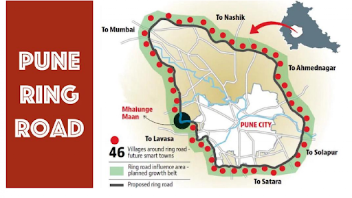
What Does the Pune Ring Road Map Show?

The pune ring road map reveals the strategic alignment connecting all major entry and exit points of the Pune Metropolitan Region. It showcases how the ring road loops around the city and joins the following highways:
- Mumbai–Pune Expressway
- Pune–Bengaluru Highway (NH-48)
- Pune–Solapur Highway (NH-65)
- Pune–Nashik Highway (NH-60)
- Pune–Ahmednagar Highway (NH-753F)
The pune ring road satellite map gives a bird’s-eye view of its proposed path, highlighting connectivity with key industrial belts such as Chakan, Talegaon, Wagholi, and Khed, as well as residential clusters like Baner, Hadapsar, and Undri.
What Are the Pune Ring Road Project Details?

Here are the comprehensive pune ring road project details as per PMRDA’s official plan:
- Total Length: 128 km
- Lanes: 6-lane access-controlled highway
- Type: Greenfield project (new alignment, not existing road widening)
- Executing Agency: PMRDA (Pune Metropolitan Region Development Authority)
- Estimated Cost: Around ₹13,000 crore
- Land Acquisition Required: Approximately 1,900 hectares
- Interchanges/Flyovers: 29 major intersections planned
- Toll Plazas: 8
- Service Roads: Included along multiple sections
- Construction Mode: Hybrid Annuity Model (HAM)
The project has been designed to meet national highway standards, ensuring durability, smooth movement, and safety compliance.
Also Read: How To Check RERA Registered Projects In Pune In 2025 | Housiey
What Is the Pune Ring Road Current Status?

As per the pune ring road current status, the PMRDA has completed a major portion of the land acquisition process and obtained environmental clearances for multiple segments.
- Around 90% of land acquisition for Phase 1 (northern section) is complete.
- The Detailed Project Report (DPR) has been finalized.
- Tendering for contractors has begun for select stretches.
- Compensation distribution to landowners is in progress under the new land acquisition norms.
- The construction work for the first leg is expected to begin soon.
The government’s renewed focus on timely execution has significantly accelerated progress compared to previous years.
What Is the Expected Pune Ring Road Completion Date?
The pune ring road completion date is expected to be around 2027, provided the construction work continues as scheduled.
Phase-wise timelines are as follows:
- Phase 1 (Northern Section): Expected by late 2026
- Phase 2 (Southern Section): Expected by mid-2027
Once completed, the road is expected to reduce travel time between Pune’s peripheries by nearly 50%.
What Does the Pune Inner Ring Road Mean for Real Estate Development?
The project is anticipated to create new growth hubs across the periphery. Areas such as Wagholi, Baner, Hinjewadi, Hadapsar, and Undri are witnessing rising interest from developers and homebuyers alike.
Improved connectivity means reduced travel times, enhanced accessibility to IT parks and industrial zones, and potential value appreciation for properties situated along or near the ring road alignment.
This infrastructural boost also aligns with the Smart City vision of Pune, promoting planned growth and balanced urban expansion.
What Are the Environmental and Social Considerations in the Project?

PMRDA has integrated several environmental safeguards in the pune inner ring road plan, such as:
- Minimal forest land encroachment.
- Compensatory afforestation.
- Noise barriers near residential zones.
- Proper drainage and water channel preservation.
- Rehabilitation and compensation packages for affected villagers.
These measures are critical to ensure the project’s sustainability and social acceptance.
Also Read: Top Developers in Pune: A Comprehensive Guide to the Best Builders in the City
How Will the Pune Ring Road Impact Traffic and Commute?

Once operational, the Pune Inner Ring Road will serve as a vital traffic dispersal route. Commuters heading towards Mumbai, Solapur, or Nashik won’t need to pass through Pune city, which will:
- Cut down congestion on key arterial roads.
- Reduce vehicular pollution levels.
- Improve traffic flow within the core city.
- Save fuel and travel time for long-distance vehicles.
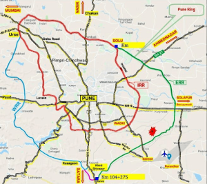
How Is the Pune Ring Road Connected to the Outer Ring Road?
While the Inner Ring Road is managed by PMRDA, the Outer Ring Road (spanning around 173 km) is being executed by the Maharashtra State Road Development Corporation (MSRDC).
Both these projects are complementary, forming a dual-layer transport ring around Pune. The inner ring will cater to intercity connectivity, while the outer ring will focus on regional and industrial traffic movement.
What Is the Pune Inner Ring Road’s Economic Significance?

This project is more than just an infrastructural link—it’s an economic catalyst. It is expected to:
- Open new corridors for logistics parks and warehousing.
- Attract investments in manufacturing zones.
- Encourage new commercial hubs near nodes like Chakan and Wagholi.
- Generate thousands of direct and indirect employment opportunities.
With such potential, the project’s completion could reshape Pune’s economic geography.
What Are the Challenges Faced in Project Execution?

While the pune ring road project details appear robust, the execution has faced hurdles:
- Land acquisition delays due to valuation disputes.
- Environmental clearance processes.
- Compensation disagreements.
- Funding and tender finalizations.
However, with political and administrative push from the Maharashtra government, most of these challenges are gradually being addressed.
Also Read: Simplifying Property Tax in Pune: A Comprehensive Guide to Paying Property Tax Online
Conclusion
The Pune Inner Ring Road is not just another infrastructure project — it’s a game-changer for Pune’s connectivity, development, and future growth. By easing congestion, creating economic corridors, and redefining the city’s transport ecosystem, it marks the dawn of a new era in urban planning.
As the pune ring road current status advances towards construction and the pune ring road completion date draws closer, Pune stands on the brink of an infrastructural revolution. For developers, homebuyers, and businesses alike, this project promises long-term benefits.
At Housiey, we bring you the most credible and up-to-date real estate insights, connecting you directly with builders — no middlemen, no hassle, just transparent property buying.
If you found this blog informative, make sure you check out our detailed post on “Mysore to Chennai Bullet Train: Route Map | Timings | Ticket Price | Update” — another transformational infrastructure project redefining regional mobility.
FAQs
- The project spans approximately 128 km.
- It encircles the Pune Metropolitan Region, connecting multiple highways and suburbs.
- The PMRDA (Pune Metropolitan Region Development Authority) is the nodal agency.
- It oversees planning, land acquisition, and construction.
- It connects Mumbai–Pune Expressway, NH-65, NH-48, NH-60, and NH-753F.
- This ensures uninterrupted intercity and intracity travel.
- Nearly 80 villages are part of the planned alignment.
- The final pune inner ring road villages list may vary slightly during execution.
- To decongest Pune’s urban roads and improve regional connectivity.
- It also aims to support urban expansion and economic zones.
- The total cost is projected at around ₹13,000 crore.
- This includes land acquisition, construction, and development expenses.
- The pune ring road completion date is expected around 2027.
- Phase-wise completion may occur earlier in certain segments.
- The pune ring road current status shows that 90% of land acquisition is done.
- Tendering and initial groundwork are already underway.
- Reduced traffic congestion, lower travel time, and better connectivity.
- It will also boost real estate and regional economic growth.
- Yes, but minimally — the route avoids densely populated zones.
- Compensation and rehabilitation plans have been set for affected villagers.
- The project has two phases: northern and southern sections.
- Each will be executed sequentially to ensure timely delivery.
- The Hybrid Annuity Model (HAM) is being used.
- This model allows public-private partnership with shared funding.
- Yes, tolls will be implemented for maintenance and operational costs.
- Eight toll plazas are currently planned.
- Areas near the alignment may see significant appreciation.
- Improved connectivity tends to attract developers and investors.
- The project includes afforestation, noise control, and water management.
- Environmental impact assessments have been approved.
- Land disputes and funding delays were key challenges.
- However, the PMRDA has resolved most issues for smoother progress.
- The inner ring focuses on intra-city connectivity.
- The outer ring serves larger regional traffic between highways.
- Yes, 29 major flyovers and interchanges are planned.
- These ensure seamless transitions between major highways.
- Around 1,900 hectares of land is needed.
- Most acquisition is near completion.
- Travel time across Pune’s periphery will reduce by up to 50%.
- It will also ease pressure on central Pune roads.
L. Sadriwala, the Editor-in-Chief at Housiey, is a seasoned writer whose professional journey in content creation began in 2015. With a background rooted in a family of real estate developers, her transition into real estate writing was a natural evolution, bringing together her storytelling expertise and deep industry understanding.
Over the years, she has authored impactful blogs across diverse niches such as food, travel, and lifestyle, before establishing her reputation as a trusted voice in Indian real estate. Today, her work stands out for its clarity, accuracy, and ability to simplify complex property concepts for readers.
At Housiey, every article crafted by L. Sadriwala reflects thorough research, verified facts, and a reader-first approach. From decoding housing policies and trends to offering in-depth builder reviews and project insights, her mission is clear: to empower homebuyers and investors with the knowledge they need to make confident property decisions.
Her writing not only informs but also builds trust, making her one of the most credible editorial voices in the real estate space.
Related Stories