
Mumbai Trans Harbour Link: Map | Photos | Connectivity – Housiey
-
By Zeeshan Qureshi
- May 9, 2025
The dream of seamless travel between Mumbai and Navi Mumbai has finally come true with the opening of the iconic Mumbai Trans Harbour Link (MTHL). Officially named the Atal Setu Mumbai Shri Atal Bihari Vajpayee Trans Harbour Link Mumbai Maharashtra, this mega infrastructure marvel is now India’s longest sea bridge. Spanning across the Arabian Sea, the link promises to transform connectivity, reduce travel time, and boost real estate potential across the Mumbai Metropolitan Region (MMR).
In this detailed blog by Housiey, we will cover every single aspect of the Mumbai Trans Harbour Link — from the Mumbai Trans Harbour Link map, stunning Mumbai Trans Harbour Link photos, connectivity routes, toll charges, project details, cost, distance, and more. Whether you are preparing for the Mumbai Trans Harbour Link UPSC exam topic or planning your commute, this is your one-stop guide.
Introduction: Mumbai’s Giant Leap in Connectivity
For decades, commuters and city planners dreamed of a direct link connecting Mumbai Island City with the rapidly developing Navi Mumbai. That vision materialized through the Mumbai Trans Harbour Link project, a 22 km engineering wonder that cuts down the travel time between Mumbai and Navi Mumbai from over 2 hours to just about 20-30 minutes.
Officially inaugurated as the Atal Setu, named after former Prime Minister Shri Atal Bihari Vajpayee, this sea bridge isn’t just a road — it’s a lifeline for Mumbai’s future urban expansion.
Let’s dive deep into its details.
Mumbai Trans Harbour Link: Project Details

The Mumbai Trans Harbour Link project is a collaborative endeavor by the Mumbai Metropolitan Region Development Authority (MMRDA) with support from the Japan International Cooperation Agency (JICA). Here are the key Mumbai Trans Harbour Link project details you should know:
- Total Length: 21.8 km (18 km over sea + 3.8 km over land)
- Mumbai Trans Harbour Link route: Sewri (Mumbai) to Chirle (Navi Mumbai)
- Lanes: 6-lane freeway (3 lanes in each direction)
- Construction Cost: Approximately INR 17,843 crore
- Opening Date: January 12, 2024
The MTHL is built with cutting-edge technology, designed to withstand high winds, heavy traffic, and corrosion from the saline environment.
Mumbai Trans Harbour Link: Map Overview

If you’re looking for the Mumbai Trans Harbour Link map, you’ll notice that the bridge connects:
- Sewri (South Mumbai) → passing over Thane Creek → connecting to Chirle near Nhava Sheva (Navi Mumbai).
Key interchanges and linkages:
- Eastern Freeway
- Mumbai Port Road
- JNPT Port Road
- Mumbai Pune Expressway (via Navi Mumbai)
This strategic alignment will decongest existing routes like the Sion-Panvel Highway and Eastern Express Highway.
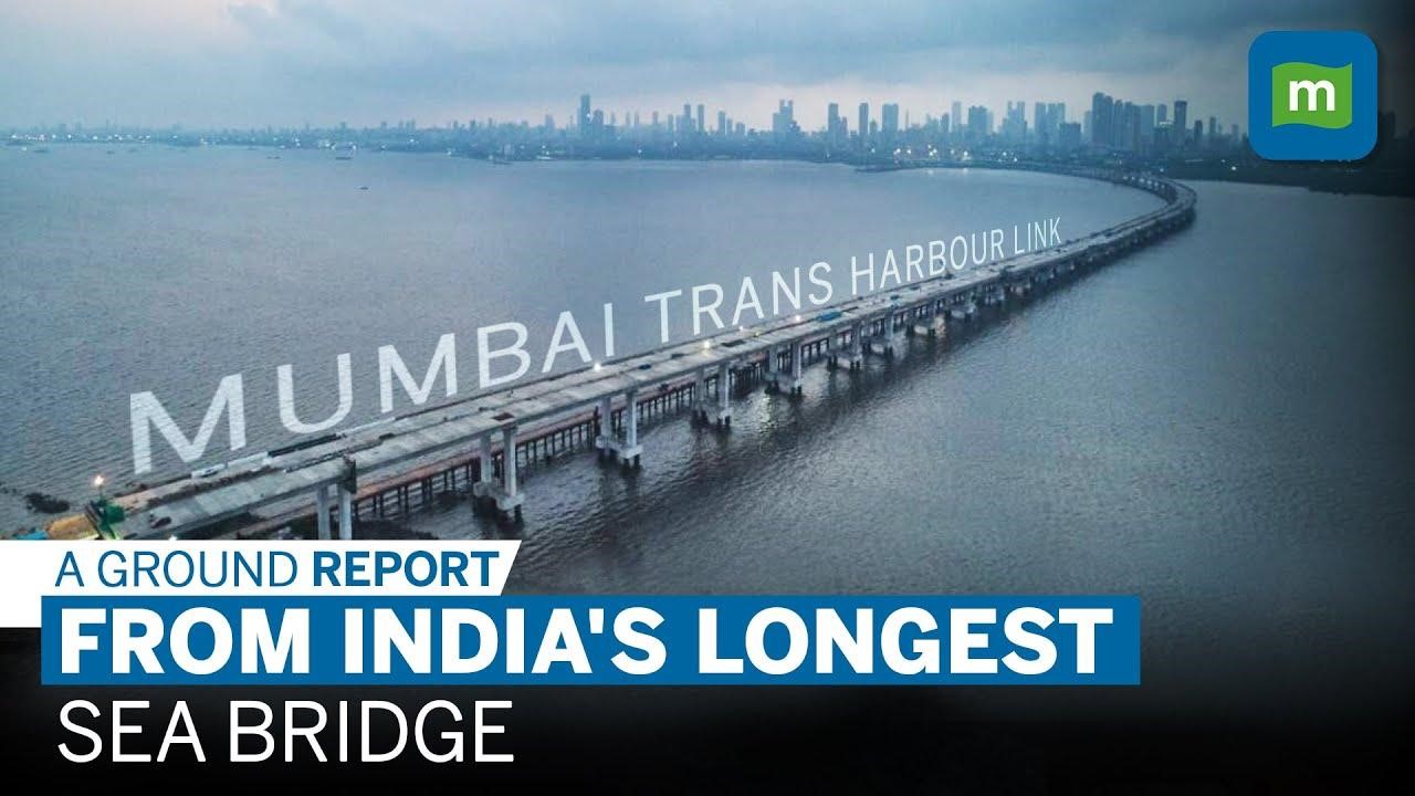
Mumbai Trans Harbour Link: Photos Showcasing India’s Longest Sea Bridge


The Mumbai Trans Harbour Link photos circulating across the web showcase breathtaking aerial views of this grand structure. Sleek, modern, and robust — MTHL stands as a symbol of India’s engineering prowess. Night photos with illuminated deck slab lighting add to its aesthetic appeal.
From drone shots showing the bridge slicing through the Arabian Sea to close-ups of the towering pylons, every image confirms why this is a landmark project in India’s infrastructure history.
Mumbai Trans Harbour Link Route and Length

Let’s look at the Mumbai Trans Harbour Link route and Mumbai Trans Harbour Link length more systematically:
- Starting Point: Sewri (Mumbai)
- Midspan: Over Thane Creek, with navigational channels for ships
- Ending Point: Chirle, near JNPT in Navi Mumbai
- Total Distance: 21.8 km
This makes the MTHL not just Mumbai’s, but India’s longest sea bridge by distance — an incredible achievement.
Mumbai Trans Harbour Link Opening Date and Naming Details
When Did MTHL Open?
The Mumbai Trans Harbour Link opening date was January 12, 2024. The inauguration by the Prime Minister marked the beginning of a new era in Mumbai’s commuting history.
Named After Whom?

Many are curious to know, after which person is the Mumbai Trans Harbour Link, India’s longest sea bridge, named? It is named after the late Shri Atal Bihari Vajpayee, one of India’s most respected leaders, and is officially called the Atal Setu Mumbai Shri Atal Bihari Vajpayee Trans Harbour Link Mumbai Maharashtra.
Mumbai Trans Harbour Link Connectivity: How It Transforms Travel
The Mumbai Trans Harbour Link connects two major urban clusters:
- Mumbai (India’s financial capital)
- Navi Mumbai (emerging commercial and residential hub)
Key connectivity benefits:
- Seamless travel to Navi Mumbai International Airport (NMIA)
- Faster access to JNPT Port
- Quicker route to Mumbai Pune Expressway
- Decongestion of Sion-Panvel route and Vashi Bridge
With this link, developers predict a real estate boom in areas like Ulwe, Panvel, and Dronagiri, thanks to improved access.
Mumbai Trans Harbour Link Cost and Funding

The Mumbai Trans Harbour Link cost is pegged at around INR 20,000 crore, funded by:
- 85% loan assistance from JICA
- Remaining 15% from MMRDA and Government of Maharashtra
Given the scale, the cost is justified by the long-term benefits this project will yield across urban transport, logistics, and real estate.
Mumbai Trans Harbour Link Toll Charges
The project comes with toll collection to recover construction and maintenance costs. Here are the approximate Mumbai Trans Harbour Link toll charges:
- Cars / Light Vehicles: INR 250 – INR 300 (one-way)
- Heavy Vehicles: Higher slabs, based on axle count
Regular commuters can avail of monthly pass discounts, making it economical for daily users.
Mumbai Trans Harbour Link Distance and Travel Time Savings
- Mumbai Trans Harbour Link distance: 21.8 km
- Travel time saved:
-
- Old route (via Vashi Bridge): 2-2.5 hours during peak
- New route (via MTHL): 20-30 minutes end-to-end
This reduction is a game changer for daily commuters, logistics firms, and even emergency services.
Mumbai Trans Harbour Link: A Boon for Real Estate & Economy
Real estate analysts expect a surge in property demand and prices in areas connected by the bridge:
- Ulwe: Already seeing price appreciation
- Panvel: Gaining popularity as an affordable hub
- Dronagiri: Emerging hotspot
- Chirle and Nhava Sheva: Potential future growth zones
The Mumbai Trans Harbour Sea Link acts as a catalyst for MMR’s overall urban and economic expansion.
Mumbai Trans Harbour Link UPSC Relevance
If you’re preparing for Mumbai Trans Harbour Link UPSC-related questions, remember:
- It’s India’s longest sea bridge (21.8 km)
- Named after Atal Bihari Vajpayee
- Connects Sewri (Mumbai) to Chirle (Navi Mumbai)
- Funded majorly by JICA
- Boosts trade, logistics, real estate, and urban development in MMR
Conclusion: Mumbai’s Lifeline for the Future
The Mumbai Trans Harbour Link (MTHL) is more than a bridge — it’s a futuristic corridor connecting the past, present, and future of Mumbai and Navi Mumbai. By cutting down travel time, boosting logistics efficiency, and opening up new real estate frontiers, it paves the way for the next phase of Mumbai’s urban story.
At Housiey, we are excited about how this link will positively impact homebuyers and investors. Areas once considered remote are now prime spots thanks to enhanced connectivity.
Looking to explore housing schemes across India? Don’t forget to read our blog on “Punjab Housing Scheme 2025“ for more valuable insights.
FAQs
-
- 21.8 km, making it India’s longest sea bridge.
-
- Sewri in Mumbai to Chirle in Navi Mumbai.
-
- Atal Setu Mumbai Shri Atal Bihari Vajpayee Trans Harbour Link Mumbai Maharashtra.
-
- January 12, 2024.
-
- Approximately INR 17,843 crore.
-
- Major funding from JICA and the rest by MMRDA and the Government of Maharashtra.
-
- Around INR 250-300 for light vehicles (one-way).
-
- Reduces travel from over 2 hours to about 20-30 minutes.
-
- Yes, it is.
-
- From Sewri (Mumbai) to Chirle (Navi Mumbai) over Thane Creek.
-
- Boosts property demand and prices in Navi Mumbai regions like Ulwe and Panvel.
-
- Yes, with applicable toll charges based on axle count.
-
- Yes, discounted monthly passes are available.
-
- It’s a key infrastructure topic relevant under urban development and transport.
-
- Photos showcasing its engineering, night lighting, and aerial views are widely shared online.
-
- Around 18 km of the total 21.8 km span is over the sea.
-
- Yes, it provides faster access to NMIA.
-
- Eastern Freeway, JNPT Road, and Mumbai Pune Expressway.
-
- After former Prime Minister Shri Atal Bihari Vajpayee.
-
- Check out Housiey’s blog on “Punjab Housing Scheme 2025”.
I am Zeeshan Qureshi, a dedicated content writer for Housiey.com, passionate about simplifying the home-buying journey for everyone. With strong expertise in the real estate industry, I strive to offer transparent, reliable, and up-to-date information that empowers homebuyers to make smart property decisions.
My articles, guides, and project reviews reinforce Housiey’s core values—No Brokerage Policy and Bottom Rate Guarantee—ensuring every reader gets genuine market insight, legal clarity, and the most recent trends.
Through Housiey Blogs, I aim to provide readers with valuable knowledge on topics like Real Estate Law, RERA, Stamp Duty, Home Loans, Vastu Tips, and the latest property market updates, blending useful information with a touch of lifestyle, sports, and entertainment content.
Specialization: Project analysis, government policy explainers, financial guidance, home design tips.
Mission: To empower Indian families with trustworthy knowledge for their dream home purchase.
Writing Style: Making complex real estate topics easily understandable and engaging for every reader.
If you are seeking answers to your property questions or want to stay updated with the latest real estate trends, stay connected with Housiey Blogs—where you’ll always find insight, trust, and real-world guidance.
Related Stories