UP Ganga Expressway Route: Map | Village List | Completion Date
-
By Ayush Oswal
- July 4, 2026
Introduction
The UP Ganga Expressway is one of India’s most ambitious greenfield expressway projects, designed to transform connectivity across Uttar Pradesh. Stretching from the western part of the state to the eastern region, this mega infrastructure project is expected to reduce travel time, improve logistics, encourage industrial development, and boost real estate growth along its corridor.
Once operational, the expressway will connect several districts, making travel faster and creating new economic opportunities for businesses, industries, farmers, and homebuyers. In this blog, let’s explore the UP Ganga Expressway route, map, village list, districts covered, construction status, expected completion date, and its impact on real estate.
Quick Answer
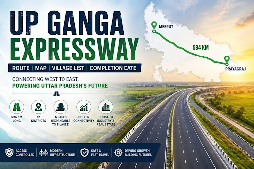
The UP Ganga Expressway is a 594-km access-controlled six-lane expressway (expandable to eight lanes) connecting Meerut to Prayagraj. It passes through 12 districts, hundreds of villages, and is expected to be substantially completed by late 2025, subject to construction progress and government timelines.
Also Read: Shaktipeeth Expressway: Route Map | Completion Date | Village List | Status
Market Snapshot Table
| Particular | Details |
|---|---|
| Project Name | UP Ganga Expressway |
| Length | Approximately 594 km |
| Starting Point | Meerut |
| Ending Point | Prayagraj |
| Lanes | 6 (Expandable to 8) |
| Districts Covered | 12 |
| Implementing Agency | Uttar Pradesh Expressways Industrial Development Authority (UPEIDA) |
| Purpose | Faster connectivity and regional development |
| Expected Completion | Late 2025 (subject to project progress) |
What is the UP Ganga Expressway?
The UP Ganga Expressway is a high-speed access-controlled expressway being developed by the Uttar Pradesh government through UPEIDA.
The project aims to:
- Improve east-west connectivity
- Reduce travel time across Uttar Pradesh
- Promote industrial investment
- Improve freight transportation
- Support tourism and agriculture
- Generate employment opportunities
- Encourage new residential and commercial developments
It is among the longest expressways being built in India.
UP Ganga Expressway Route
The expressway begins from Meerut and terminates at Prayagraj, connecting major cities and rural regions across central Uttar Pradesh.
The route has been carefully planned to minimize travel time while improving connectivity between developing districts.
Also Read: KMP Expressway in 2026: Route Map | Toll Charges | Speed Limit
Major Route
Meerut → Hapur → Bulandshahr → Amroha → Sambhal → Badaun → Shahjahanpur → Hardoi → Unnao → Rae Bareli → Pratapgarh → Prayagraj
The alignment also connects several state highways, district roads, and future industrial corridors.
UP Ganga Expressway Map Overview
Although the detailed engineering map is available through official planning authorities, the route broadly runs in a west-to-east direction across Uttar Pradesh.
Key highlights include:
- Multiple interchanges
- Toll plazas
- Service roads
- Bridges over rivers
- Rail overbridges
- Underpasses
- Emergency services
- Future industrial nodes
The expressway has also been designed with provisions for future expansion and modern traffic management systems.
Districts Covered
The expressway passes through 12 districts:
- Meerut
- Hapur
- Bulandshahr
- Amroha
- Sambhal
- Badaun
- Shahjahanpur
- Hardoi
- Unnao
- Rae Bareli
- Pratapgarh
- Prayagraj
These districts are expected to witness increased infrastructure investments and better regional connectivity.
Also Read: Delhi – Jaipur Expressway: Route Map | Opening Date | Distance | News
UP Ganga Expressway Village List
The project affects hundreds of villages across its alignment. Since the complete acquisition list is extensive and revised periodically, below are some of the villages covered in different districts.
Meerut District
- Bahsuma region villages
- Nearby agricultural settlements
Hapur District
- Several villages around Garhmukteshwar
Bulandshahr District
- Villages near Anupshahr corridor
Amroha District
- Multiple rural settlements along the alignment
Sambhal District
- Villages adjoining the proposed expressway corridor
Badaun District
- Agricultural villages connected through feeder roads
Hardoi, Unnao, Rae Bareli, Pratapgarh and Prayagraj
Numerous villages have been included for land acquisition and connectivity improvements under different construction packages.
For the latest and complete village-wise land acquisition details, property owners should refer to the latest notifications issued by UPEIDA and respective district administrations.
Construction Status
Construction has been progressing in multiple packages simultaneously.
Major works include:
- Earthwork
- Bridge construction
- Flyovers
- Culverts
- Pavement laying
- Interchanges
- Toll infrastructure
Several sections have recorded significant physical progress, while finishing work continues in remaining stretches.
Also Read: Delhi Mumbai Expressway: Route Map | Status | Village List | News
Expected Completion Date
According to the latest government updates, the UP Ganga Expressway is expected to be substantially completed by late 2025, although timelines may vary depending on weather conditions, land-related issues, and construction progress.
Once operational, the expressway will become one of Uttar Pradesh’s major transportation corridors.
Benefits of the UP Ganga Expressway
Improved Connectivity
Travel between western and eastern Uttar Pradesh will become significantly faster.
Boost to Real Estate
Areas located near interchanges are expected to witness increased residential and commercial development.
Industrial Growth
Improved road infrastructure is likely to attract manufacturing units, warehouses, and logistics parks.
Better Agricultural Transportation
Farmers can transport produce more efficiently to major markets.
Employment Generation
Construction activities and future commercial development are expected to create thousands of direct and indirect jobs.
Buyer Insights
For homebuyers and investors, the UP Ganga Expressway presents opportunities in emerging locations where infrastructure development often drives long-term appreciation. However, buyers should verify land titles, zoning regulations, and approved development plans before making investment decisions.
Why Buyers Choose Housiey
Housiey simplifies the property-buying journey by connecting buyers directly with reputed builders. The platform offers transparent guidance, verified project information, and a smoother home-buying experience without unnecessary intermediary complications.
Conclusion
The UP Ganga Expressway is set to become one of Uttar Pradesh’s most transformative infrastructure projects. By connecting Meerut to Prayagraj through a modern access-controlled corridor, it is expected to improve mobility, strengthen logistics, encourage industrial growth, and unlock new opportunities for residential and commercial development.
As construction moves toward completion, districts and villages along the route are likely to benefit from improved accessibility and increased economic activity, making the expressway a significant milestone in the state’s infrastructure development.
Key Takeaways
- The UP Ganga Expressway is approximately 594 km long.
- It connects Meerut with Prayagraj.
- The expressway passes through 12 districts.
- It is a six-lane expressway expandable to eight lanes.
- Hundreds of villages fall along the project alignment.
- The project is expected to substantially complete by late 2025.
- It will improve logistics, tourism, agriculture, and industrial growth.
- Real estate demand may increase near major interchanges.
- The project includes bridges, interchanges, service roads, and modern safety infrastructure.
- Buyers should always verify official land acquisition notifications before investing.
Sources
- Uttar Pradesh Expressways Industrial Development Authority (UPEIDA)
- Ministry of Road Transport and Highways (MoRTH)
- Government of Uttar Pradesh
- National Highways Authority of India (reference material)
- Official project notifications and district administration land acquisition updates
- Publicly available government infrastructure reports
FAQs
- The expressway is approximately 594 km long. It is among the longest access-controlled expressways in India.
- The expressway begins in Meerut district. It provides a major west-to-east transportation corridor across Uttar Pradesh.
- It terminates in Prayagraj. This connection significantly improves travel across the state.
- The expressway passes through 12 districts. These districts are expected to benefit from improved connectivity and economic growth.
- It is being built as a six-lane expressway. It can be expanded to eight lanes in the future.
- The project is being implemented by UPEIDA. The authority is responsible for planning and execution.
- The project is expected to be substantially completed by late 2025. Actual commissioning may vary depending on construction progress.
- Yes, it is designed to significantly reduce travel time. It also improves travel safety and efficiency.
- Yes, it passes through hundreds of villages across different districts. Land acquisition has been carried out in multiple phases.
- Yes, official acquisition records may be updated from time to time. Property owners should verify the latest government notifications.
- Yes, faster movement of goods is one of its primary objectives. This can lower transportation costs over time.
- Yes, entry and exit are permitted only through designated interchanges. This helps maintain higher travel speeds and safety.
- Yes, improved connectivity can encourage industrial and logistics investments. Better infrastructure often attracts new businesses.
- The expressway can provide quicker access to markets. This may reduce transportation time for agricultural produce.
- Yes, areas near interchanges may witness increased demand. Infrastructure projects often contribute to long-term property appreciation.
- Yes, the expressway will operate as a tolled corridor. Users will need to pay applicable toll charges.
- Yes, service roads are planned in selected stretches. They improve local connectivity for nearby communities.
- Where can I check official project updates?Yes, the expressway includes provisions for emergency response and safety infrastructure. These features enhance commuter safety.
- Official updates are released by UPEIDA and the Uttar Pradesh Government. District administrations also publish relevant notifications.
- It is expected to transform connectivity across Uttar Pradesh. The project also supports economic development, investment, and regional growth.
Ayush Oswal is an SEO Executive at Housiey, specializing in optimizing real estate content for better visibility and engagement. With a strong understanding of SEO strategies and the property market, he ensures that every blog helps homebuyers make informed decisions while performing well on search engines.
Related Stories