Samruddhi Mahamarg Route Map: | Distance | Opening Date | News
-
By Zeeshan Qureshi
- June 28, 2025
The Hindu Hrudaysamrat Balasaheb Thackeray Maharashtra Samruddhi Mahamarg, more popularly known as Samruddhi Mahamarg, is one of India’s most ambitious expressway projects. Stretching across Maharashtra, it connects the state capital Mumbai (via the Mumbai–Nagpur route) to the second capital Nagpur with world-class infrastructure. The project has been touted as a game-changer for transportation, logistics, and regional development.
This blog takes a deep dive into all aspects of the expressway: its distance, route map, phases, toll charges, exit points, news updates, accident concerns, and the numerous advantages it offers. Whether you are a traveler, investor, or simply curious about India’s infrastructure growth, this guide will provide you with every crucial detail.
Apna Ghar, Apni Mumbai – Make It Yours!
Don’t just visit Mumbai – Own a piece of it! Direct from Builders – No Brokerage!
Don’t Miss Mumbai’s Best Deals →What Are the Samruddhi Mahamarg Details?
The Samruddhi Mahamarg is a 701-km long, 8-lane access-controlled expressway connecting Nagpur to Mumbai via districts like Wardha, Amravati, Washim, Buldhana, Jalna, Aurangabad, Nashik, and Thane.
- Length: 701 km
- Lanes: 8-lane (expandable to 10 lanes)
- Connecting Cities: Nagpur, Aurangabad, Nashik, Thane, Mumbai
- Districts Covered: 10 major districts of Maharashtra
- Project Cost: Estimated at ₹55,000 crore
It is designed to reduce travel time between Nagpur and Mumbai from 16–18 hours to just 8 hours.
Also Read:- NH44 National Highway: Route | Map | Distance | News
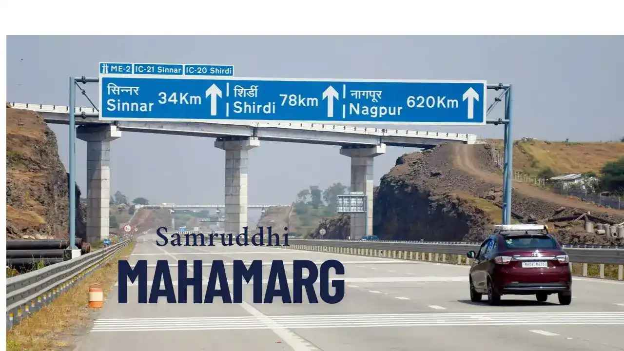
What Is the Samruddhi Mahamarg Route Map Start to End?

The Samruddhi Mahamarg route map start to end runs from Nagpur (Zero Mile) to Mumbai (Shahpur near Thane).
Key points on the route:
- Nagpur (Zero Mile) – Starting point
- Wardha
- Amravati
- Washim
- Buldhana
- Jalna
- Aurangabad
- Nashik
- Thane (Shahpur) – Ending point
The route has been planned to ensure direct connectivity to major industrial and agricultural hubs of Maharashtra.
Also Read:- Top 10 Longest Roads in the World: A Journey Through Endless Highways
How Long Is the Samruddhi Mahamarg Distance?
The total Samruddhi Mahamarg distance is 701 km.
- Nagpur to Aurangabad: ~450 km
- Aurangabad to Nashik: ~200 km
- Nashik to Thane (Mumbai): ~51 km
This makes it one of India’s longest expressways, comparable to the Delhi–Mumbai Expressway.
Pune Real Estate – Smart City, Smarter Investment!
Smart city, smart homes – Pune’s best verified projects – No Brokerage!
Find My Perfect Pune Home →What Are the Samruddhi Mahamarg Phases’ Route?
The project has been developed in phases for systematic completion:
- Phase 1: Nagpur to Shirdi (520 km) – Inaugurated in December 2022.
- Phase 2: Shirdi to Bharvir (in Nashik district) – Opened in 2023.
- Phase 3: Bharvir to Thane (near Mumbai) – The final leg.
With the completion of all phases, the expressway is now fully functional, enabling seamless connectivity between Nagpur and Mumbai.
Also Read:- Jewar Airport Connectivity Map: Yamuna Expressway | DME & Metro Plans
What Are the Samruddhi Mahamarg Exit Points?
To facilitate smooth entry and exit, the expressway has several exit points across districts.
Key exit points include:
- Nagpur (Zero Mile, starting point)
- Wardha
- Amravati
- Karanja (Washim)
- Mehkar (Buldhana)
- Jalna
- Aurangabad
- Vaijapur (Aurangabad district)
- Nashik district exits
- Shahpur, Thane (end point near Mumbai)
These exits allow access to local towns, industrial hubs, and highways, boosting connectivity.
What Are the Samruddhi Mahamarg Toll Charges?

The Samruddhi Mahamarg toll charges depend on vehicle type and distance traveled. Toll plazas are placed at intervals, and electronic toll collection systems like FASTag are enabled.
Approximate charges (as per initial announcements):
- Cars/Light Vehicles: ₹1.65–₹2.10 per km
- Buses/LCVs: ₹5.45 per km
- Heavy Vehicles/Trucks: ₹7–₹10 per km
For example:
- Nagpur to Shirdi (520 km) in a car: ₹1,200–₹1,300 approx.
- Full stretch Nagpur to Mumbai (701 km) in a car: ₹1,500–₹1,700 approx.
Bangalore is Booming – Don’t Miss Your Chance!
Bangalore’s skyline is rising fast – grab your RERA-verified home directly from Builders – No Brokerage!
See Why Bangalore is Trending →What About Samruddhi Mahamarg Accident Concerns?
While the expressway has reduced travel time, it has also seen several accidents due to:
- Overspeeding
- Driver fatigue
- Sudden lane changing
Authorities have responded by:
- Installing CCTV cameras
- Strict speed monitoring
- Adding service lanes and rest areas
- Increasing patrol units
Travelers are advised to drive cautiously and avoid speeding.
What Are the Samruddhi Mahamarg Advantages?

The advantages of Samruddhi Mahamarg are immense:
- Travel Efficiency – Nagpur to Mumbai in 8 hours.
- Boost to Economy – Better movement of goods, industries, and logistics.
- Tourism Growth – Access to Shirdi, Ajanta, Ellora, Lonar Lake, and Nashik vineyards.
- Urban Development – New townships and industrial hubs along the route.
- Agricultural Benefits – Farmers get quicker access to Mumbai and export hubs.
- Employment Generation – Thousands of jobs in construction, toll operations, and allied services.
- Emergency Access – Faster transportation for medical emergencies.
What Is the Latest Samruddhi Mahamarg News?
Recent Samruddhi Mahamarg news highlights:
- The full route from Nagpur to Mumbai is operational.
- Government has announced wayside amenities like food courts, fuel stations, and rest houses.
- Smart surveillance and AI-based traffic management systems are being added.
- Plans are underway to connect Samruddhi Mahamarg to Delhi–Mumbai Expressway for national integration.
Hyderabad is on Fire – Don’t Miss Your Chance!
Hyderabad’s best residential projects for families & investors – Buy Directly – No Brokerage!
Grab Your Hyderabad Home Now →Conclusion
The Samruddhi Mahamarg is more than just a road—it is a corridor of progress for Maharashtra. With its 701 km stretch, multiple exit points, toll systems, and connectivity to key cities, it redefines travel between Nagpur and Mumbai. While concerns about accidents persist, government measures aim to ensure safer journeys.
For homebuyers and investors, the infrastructure boost from this expressway will enhance property values and development prospects along the route. At Housiey, we believe such landmark projects will pave the way for smarter living and better connectivity.
If you found this blog useful, don’t miss our in-depth coverage on CIDCO Housing Scheme—a must-read for anyone exploring real estate opportunities in Maharashtra.
FAQs
- The expressway stretches 701 km.
- It connects Nagpur to Mumbai.
- It connects Nagpur, Aurangabad, Nashik, and Mumbai.
- Many smaller towns and districts also lie along the route.
- Travel time is reduced to about 8 hours.
- Earlier, the same journey took 16–18 hours.
- The project was divided into three phases.
- Now, all phases are completed and operational.
- The project cost is around ₹55,000 crore.
- It is one of Maharashtra’s largest infrastructure investments.
- It starts from Nagpur and ends at Thane near Mumbai.
- The route passes through 10 districts.
- Several exits are located across districts like Wardha, Aurangabad, and Nashik.
- These exits connect travelers to local highways and towns.
- Toll varies based on vehicle type and distance.
- Cars usually pay around ₹1.65–₹2.10 per km.
- Yes, it is designed for all vehicle types.
- Heavy vehicles have higher toll charges.
- It is safe if drivers follow rules.
- Overspeeding has caused many accidents.
- Yes, wayside amenities are being added.
- These include fuel stations, food courts, and restrooms.
- The distance is about 520 km.
- It is covered in around 5–6 hours.
- It reduces transport time for produce.
- This increases access to markets and exports.
- Shirdi, Ajanta, Ellora, and Lonar Lake are nearby.
- Nashik’s vineyards are also easily accessible.
- Overspeeding and fatigue are major causes.
- Government is addressing them with patrols and cameras.
- Yes, it links to national and state highways.
- Plans exist to connect it with Delhi–Mumbai Expressway.
- It boosts trade and logistics.
- New industrial hubs are being created.
- Yes, smoother traffic reduces fuel use.
- Lesser congestion cuts down emissions.
- Yes, new smart cities and logistics parks are planned.
- This will support urban growth along the corridor.
- It connects east and west Maharashtra seamlessly.
- It symbolizes progress and modern infrastructure.
I am Zeeshan Qureshi, a dedicated content writer for Housiey.com, passionate about simplifying the home-buying journey for everyone. With strong expertise in the real estate industry, I strive to offer transparent, reliable, and up-to-date information that empowers homebuyers to make smart property decisions.
My articles, guides, and project reviews reinforce Housiey’s core values—No Brokerage Policy and Bottom Rate Guarantee—ensuring every reader gets genuine market insight, legal clarity, and the most recent trends.
Through Housiey Blogs, I aim to provide readers with valuable knowledge on topics like Real Estate Law, RERA, Stamp Duty, Home Loans, Vastu Tips, and the latest property market updates, blending useful information with a touch of lifestyle, sports, and entertainment content.
Specialization: Project analysis, government policy explainers, financial guidance, home design tips.
Mission: To empower Indian families with trustworthy knowledge for their dream home purchase.
Writing Style: Making complex real estate topics easily understandable and engaging for every reader.
If you are seeking answers to your property questions or want to stay updated with the latest real estate trends, stay connected with Housiey Blogs—where you’ll always find insight, trust, and real-world guidance.
Related Stories