
Virar Alibaug Corridor: Road Map | Status | Village List | Latest News
-
 By L. Sadriwala
- October 23, 2025
Introduction
The Virar–Alibaug Corridor—also known as the Virar Alibaug Multimodal Corridor (MMC)—is one of Maharashtra’s most ambitious infrastructure projects, designed to completely transform connectivity across the Mumbai Metropolitan Region (MMR). Stretching across multiple districts, this corridor aims to connect the fast-growing northern suburb of Virar to the scenic coastal town of Alibaug, seamlessly linking the western, central, and southern parts of the region.
Once completed, this project will not only decongest Mumbai’s overcrowded roadways but also stimulate economic growth in the surrounding areas by enabling faster transport of goods, services, and people. The Virar–Alibaug Corridor will serve as a backbone for regional development, connecting new townships, industrial zones, ports, and logistics hubs.
This in-depth blog systematically explores the Virar–Alibaug Corridor road map, status, village list, and latest updates, providing clarity on every aspect—from the planning and design stages to its strategic importance.
Also Read:- Mumbai Hyderabad Bullet Train: Route | Completion Date | News
What Is the Virar Alibaug Multimodal Corridor?

The Virar Alibaug Multimodal Corridor (MMC) is a massive infrastructure initiative led by the Mumbai Metropolitan Region Development Authority (MMRDA). Spanning approximately 126 km, it is envisioned as a multimodal transport corridor integrating roadways, metro rail, and utility lines within the same right-of-way.
The corridor is designed to connect Virar in Palghar district to Alibaug in Raigad district, passing through Thane and Mumbai suburban areas. It will act as a crucial link between the western and eastern corridors of Mumbai, easing traffic load on existing routes like the Western Express Highway and the Eastern Express Highway.
Key Objectives of the Corridor:
- Enhance regional connectivity across MMR.
- Promote balanced urban development beyond Mumbai’s saturated core.
- Facilitate industrial growth along the Vasai–Panvel belt.
- Provide alternate routes for freight traffic to avoid city congestion.
- Reduce travel time between Virar and Alibaug from over 3 hours to less than 90 minutes.
Also Read:- Property Boom Around Jewar Airport: Best Areas to Watch Now
What Is the Route of the Virar–Alibaug Corridor?

The Virar–Alibaug Corridor route will stretch from Navghar (near Virar) to Chowk (near Alibaug), covering approximately 126 km and passing through Palghar, Thane, Mumbai Suburban, and Raigad districts.
It will intersect with several major expressways and highways, including:
- Mumbai–Ahmedabad National Highway (NH-8)
- Mumbai–Agra National Highway (NH-3)
- Mumbai–Pune Expressway
- JNPT Port Road
- Mumbai–Vadodara Expressway
- Mumbai–Nashik Highway
The Virar Alibaug Corridor route will thus serve as a north-south arterial connection integrating multiple economic zones, industrial areas, and residential hubs.
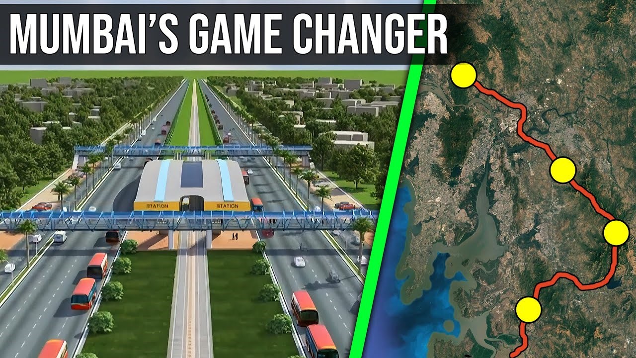
What Does the Virar Alibaug Corridor Map Show?
The Virar Alibaug Corridor map demonstrates how the project will create a linear connection cutting through multiple urban and rural regions. On the Virar–Alibaug Corridor road map, you can clearly see:
- Northern Start Point: Navghar near Virar.
- Central Section: Crossing NH-48 near Bhiwandi, and NH-4 near Taloja.
- Southern End Point: Chowk, connecting towards Alibaug and Pen.
The corridor map indicates two major phases:
- Phase 1: Virar to Chirner (around 98.5 km)
- Phase 2: Chirner to Alibaug (around 29.9 km)
Each phase will include interchanges, flyovers, and metro alignment corridors to support multimodal transportation.
Also Read:- Mumbai Vs. Bangalore Which is Better to Live
Which Villages Fall Under the Virar Alibaug Corridor?

The Alibaug–Virar Corridor villages list covers multiple talukas across Palghar, Thane, Mumbai Suburban, and Raigad districts. These include rapidly developing regions and agricultural zones expected to see massive land value appreciation.
Major Villages Under the Corridor:
- Palghar District: Virar, Navghar, Kaman, Sasunavghar, Gokhivare.
- Thane District: Bhiwandi, Kalyan, Dombivli, Shilphata, Taloja.
- Mumbai Suburban Region: Ghodbunder, Mankoli, Diva.
- Raigad District: Chirner, Pen, Chowk, and Alibaug.
The Alibaug Virar Corridor villages list will see significant infrastructure improvement, boosting local employment and housing opportunities.
What Is the Current Status of the Virar–Alibaug Corridor?
The Virar–Alibaug Corridor status shows that the project is currently under implementation with several stages completed and others in progress.
- Land acquisition is ongoing for both phases, with substantial portions of the land already acquired in Palghar and Thane.
- Detailed Project Report (DPR) and Environmental Impact Assessment (EIA) have been completed.
- MMRDA is coordinating with other agencies for the integration of the proposed metro lines along the corridor.
- Utility shifting and road design finalizations are underway in several stretches.
Once fully constructed, the Virar Alibaug Multimodal Corridor will consist of eight lanes, service roads, and a central median for the metro line.
How Is the Land Acquisition for the Virar Alibaug Corridor Progressing?

The Virar–Alibaug Corridor land acquisition process covers nearly 1,347 hectares of land across the four districts. The process has been carried out with compensation packages based on the new Land Acquisition, Rehabilitation, and Resettlement Act (2013).
MMRDA has been ensuring fair compensation for landowners while also working with local authorities to resolve disputes and relocation concerns. Areas like Virar, Bhiwandi, and Panvel have seen smoother acquisitions, while some parts near Chirner and Alibaug faced temporary resistance due to valuation issues.
However, the Virar–Alibaug Corridor latest update indicates that over 80% of the required land for Phase 1 has already been acquired, and tenders for construction have been floated.
What Is the Economic and Social Importance of the Corridor?

The Alibaug–Virar Corridor is far more than just a transportation project—it’s a transformational infrastructure corridor. It is expected to boost the economy of peripheral towns, improve interconnectivity, and encourage decentralization of Mumbai’s population.
Key Benefits:
- Decongestion of Mumbai: Diverts traffic and freight from Mumbai’s urban core.
- Economic Growth: Opens up new industrial corridors near Bhiwandi, Panvel, and Taloja.
- Real Estate Boost: Increases residential and commercial property values.
- Tourism Impact: Improves accessibility to Alibaug’s coastal areas, promoting tourism.
- Employment Generation: Creates thousands of direct and indirect jobs during and post-construction.
What Does the Virar Alibaug Corridor Mean for Real Estate Investors?
For homebuyers and investors, the Virar–Alibaug Corridor update is a signal of long-term growth opportunities. Areas like Vasai, Bhiwandi, Dombivli, Taloja, Panvel, and Alibaug are witnessing rising real estate interest due to the project’s connectivity potential.
Once completed, this corridor will seamlessly link industrial zones with residential belts, making it a major investment hotspot for affordable as well as luxury developments.
What Are the Latest Updates on the Virar Alibaug Corridor?

According to the Virar–Alibaug Corridor latest news today, the project is being fast-tracked under the state government’s infrastructure acceleration plan.
Key updates include:
- MMRDA has approved tenders for preliminary works in Phase 1.
- Construction of the first 25 km stretch between Virar and Bhiwandi has begun.
- Coordination with NHAI and CIDCO is ongoing for the integration of metro and freight corridors.
- Environmental and forest clearances for the remaining stretches are under process.
The Virar–Alibaug Corridor news suggests completion of Phase 1 by 2027 and full completion of Phase 2 by 2029, subject to timely land handover.
What Challenges Has the Project Faced So Far?

Like any large-scale infrastructure development, the Virar–Alibaug Corridor has encountered hurdles, including:
- Land acquisition delays due to valuation disputes.
- Environmental clearance issues near ecologically sensitive zones.
- Coordination between multiple agencies.
- Cost escalations from inflation and delays.
Despite these challenges, the state remains committed to completing the project, given its long-term regional importance.
Conclusion
The Virar–Alibaug Corridor represents a monumental leap forward for the Mumbai Metropolitan Region. It’s not merely a road—it’s an integrated, future-ready transportation ecosystem designed to unlock regional potential, reduce travel time, and connect millions of people across Palghar, Thane, Mumbai, and Raigad.
For investors, businesses, and daily commuters alike, this project signifies opportunity and progress. Once operational, it will redefine accessibility across Mumbai’s periphery and enable the creation of new urban centers beyond the city’s saturated limits.
At Housiey, we connect homebuyers directly with developers—making property purchases transparent, secure, and broker-free. If you’re eyeing real estate opportunities along the Virar–Alibaug Corridor, now is the time to explore.
Also, don’t miss our detailed blog on the “Shaktipeeth Expressway”—a crucial upcoming expressway that’s equally shaping Maharashtra’s infrastructure future.
FAQs
- The corridor spans approximately 126 km, connecting Virar to Alibaug through Thane and Raigad districts.
- It will be divided into two major phases for systematic construction.
- The Mumbai Metropolitan Region Development Authority (MMRDA) is overseeing its implementation.
- It is being coordinated with NHAI and CIDCO for smooth execution.
- Phase 1 covers Virar to Chirner, and Phase 2 covers Chirner to Alibaug.
- Each phase includes separate flyovers, interchanges, and metro alignments.
- The Virar–Alibaug Corridor will have eight lanes in total.
- It will also include service roads and a median for a metro line.
- It will traverse Palghar, Thane, Mumbai Suburban, and Raigad districts.
- Each region will see enhanced infrastructure and connectivity.
- Yes, over 80% of the land for Phase 1 has been acquired.
- Compensation and resettlement are being carried out under the new Land Acquisition Act.
- Phase 1 is expected by 2027, while Phase 2 may be completed by 2029.
- Timelines depend on land and clearance finalizations.
- Yes, a metro line will run along the central median.
- This feature makes it a true multimodal corridor.
- To connect western, central, and southern regions of MMR efficiently.
- It will decongest Mumbai and promote balanced growth.
- The project will cut travel time from Virar to Alibaug to just 90 minutes.
- It will also offer smoother freight movement.
- It will connect to Mumbai–Pune Expressway, NH-8, and Mumbai–Agra Highway.
- This integration ensures multi-route accessibility.
- The project cost is estimated at over ₹55,000 crore.
- The budget includes land, construction, and utility integration.
- It will significantly boost property values across MMR outskirts.
- Areas like Taloja, Panvel, and Bhiwandi are already seeing growth.
- Yes, by diverting heavy traffic away from the city core.
- It will lead to smoother vehicular flow and less congestion.
- The Ministry of Environment, Forest, and Climate Change.
- The clearances are being processed for the remaining stretches.
- Navi Mumbai International Airport and JNPT expansion are key beneficiaries.
- The corridor will support logistics and cargo operations.
- Yes, improved road connectivity will make weekend travel seamless.
- It will boost tourism-related businesses and resorts.
- It will carry both passenger and freight traffic.
- Separate lanes ensure safe and efficient movement.
- Some areas near Alibaug and Panvel are ecologically sensitive.
- MMRDA is implementing mitigation measures accordingly.
- It will generate jobs, promote trade, and stimulate regional industries.
- The corridor is expected to contribute substantially to Maharashtra’s GDP growth.
L. Sadriwala, the Editor-in-Chief at Housiey, is a seasoned writer whose professional journey in content creation began in 2015. With a background rooted in a family of real estate developers, her transition into real estate writing was a natural evolution, bringing together her storytelling expertise and deep industry understanding.
Over the years, she has authored impactful blogs across diverse niches such as food, travel, and lifestyle, before establishing her reputation as a trusted voice in Indian real estate. Today, her work stands out for its clarity, accuracy, and ability to simplify complex property concepts for readers.
At Housiey, every article crafted by L. Sadriwala reflects thorough research, verified facts, and a reader-first approach. From decoding housing policies and trends to offering in-depth builder reviews and project insights, her mission is clear: to empower homebuyers and investors with the knowledge they need to make confident property decisions.
Her writing not only informs but also builds trust, making her one of the most credible editorial voices in the real estate space.
Related Stories