Bangalore Metro Route Map: Timing | Lines | Stations
-
By Ayush Oswal
- May 25, 2026
Bangalore, now officially Bengaluru, is one of India’s most dynamic cities, brimming with innovation, IT hubs, and an ever-growing population. However, this rapid urbanization has brought with it the notorious traffic jams that Bengaluru is often infamous for. Commuting through the city’s chaotic roads used to be a daunting task for professionals, students, and tourists alike. To alleviate this congestion, Bengaluru introduced the Bangalore Metro Route, also known as Namma Metro, meaning “Our Metro” in Kannada.
Launched in 2011, Namma Metro is India’s third operational metro service after Delhi and Kolkata. This mass rapid transit system is a game-changer, connecting the city’s key residential, commercial, and industrial hubs. What sets it apart is its seamless connectivity, affordability, and commitment to being eco-friendly. With its extensive Bangalore Metro route map, the system ensures that even far-flung suburbs are well-connected to the heart of the city.
If you’ve ever wondered how to make your daily commute faster, more affordable, and stress-free, this blog will serve as your ultimate guide. From detailed information about metro lines and station lists to timings and monthly passes, we’ll cover every aspect of the Bangalore Metro map, including exciting future expansions that are set to transform the city further. Whether you’re a tech professional commuting to Whitefield or a student heading to the central business district, this blog is tailored for everyone looking to make the most of the metro system.
So, let’s dive into the details of the Bangalore Metro route map, its station network, timings, fares, and why it’s Bengaluru’s most reliable transportation solution!
Metro Connected Home in Bangalore
Explore Top RERA Approved Projects Near Namma Metro. Buy Directly — No Brokerage!
Explore Bangalore Projects →Introduction to Namma Metro
Namma Metro, meaning “Our Metro” in Kannada, is the lifeline of Bengaluru’s urban transport system. Launched in 2011, it is India’s third operational metro system after the Delhi and Kolkata Metros. The metro connects key areas, IT hubs, and suburban neighborhoods, significantly reducing travel time. Its seamless connectivity, affordable fares, and eco-friendly operations make it a preferred mode of transport for Bengaluru’s residents.
With lines running across the city’s east-west and north-south corridors, Namma Metro serves as the backbone of Bengaluru’s urban mobility. Whether you’re a tech professional, student, or tourist, the Bangalore Metro route map simplifies city travel like never before.
Live on the Purple Line – Whitefield Projects Selling Out Fast!
Top Verified Projects in Whitefield Near Metro Station. No Brokerage!
Check Whitefield Projects →Key Features of Namma Metro
Wide Coverage
- The Bangalore Metro map currently includes two main operational lines—Purple Line and Green Line—covering a significant portion of the city.
- Extensions are underway to reach peripheral areas, connecting more residential and commercial zones.
Eco-Friendly Operations
- Namma Metro relies on electric power, reducing dependency on fossil fuels.
- It is also designed to reduce Bengaluru’s carbon footprint by encouraging public transport usage.
Affordable Travel
- With fares ranging from ₹10 to ₹60 and attractive monthly pass options, the metro is cost-effective for daily commuters.
Modern Infrastructure
- Features include air-conditioned coaches, well-lit stations, escalators, elevators, and user-friendly signboards in English and Kannada.
Integrated Transit System
- The metro connects with other public transport systems, including BMTC buses, enhancing last-mile connectivity.
Yellow Line Metro is Here – Electronic City Flats at Best Prices Now!
RERA Approved Projects in Electronic City. Metro Connected – No Brokerage!
View Electronic City Projects →Detailed Bangalore Metro Lines and Routes
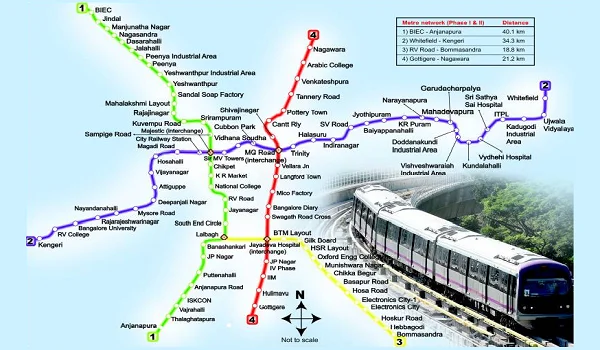
The Bangalore Metro route map currently operates on two main lines:
Purple Line: Connecting East to West
- Route: Baiyappanahalli to Whitefield (Kadugodi)
- Operational Stations: 23
Key Areas Covered:
- Baiyappanahalli: Serves as a major transit hub.
- MG Road: A prominent commercial and tourist destination.
- Indiranagar: A popular residential and nightlife hub.
- KR Puram: An essential junction for IT professionals.
- Whitefield: Bengaluru’s primary IT corridor and residential area.
Importance:
- It connects IT hubs, shopping districts, and residential zones, significantly reducing commute times.
- The Purple Line is crucial for professionals working in Whitefield, as highlighted in the Bangalore Metro map Whitefield.
Green Line: Connecting North to South
Route:
- Nagasandra to Silk Institute
Operational Stations:
- 29
Key Areas Covered:
- Nagasandra: An industrial and residential area.
- Yeshwanthpur: A significant railway station and market hub.
- Rajajinagar: A bustling residential and commercial area.
- Jayanagar: One of Bengaluru’s oldest and most prominent neighborhoods.
- Silk Institute: Serving the southern outskirts of the city.
Importance:
- Links Bengaluru’s industrial zones with its central and southern areas.
- Facilitates travel to prominent educational institutions and residential areas.
Green Line Metro + Dream Home – Banashankari is Your Perfect Address!
Verified Projects in Banashankari Near Metro. Buy Smart – Zero Brokerage!
Find Banashankari Projects →Complete Bangalore Metro Stations List
Here’s the complete Bangalore Metro stations list for both operational lines:
Purple Line Stations
|
Station Number | Station Name | Interchange/Key Highlights |
|---|---|---|
|
1 |
Kengeri |
Upcoming residential and commercial hub |
|
2 |
Jnana Bharathi |
Close to Bangalore University |
|
3 |
Nayandahalli |
Well-connected to Mysore Road |
|
4 |
Rajarajeshwari Nagar |
Major residential area |
|
5 |
Deepanjali Nagar |
Proximity to Rajajinagar and Vijayanagar |
|
6 |
Mysore Road |
Industrial hub |
|
7 |
Attiguppe |
Residential area |
|
8 |
Vijayanagar |
Popular shopping and residential zone |
|
9 |
Magadi Road |
Connects to key city areas |
|
10 |
Hosahalli |
Residential zone |
|
11 |
Vijaynagar Metro Station |
Proximity to lifestyle stores |
|
12 |
Kempegowda Majestic (Interchange) |
Main interchange with the Green Line |
|
13 |
MG Road |
Prime shopping and nightlife hub |
|
14 |
Baiyappanahalli |
Connectivity to Whitefield & IT hubs |
Green Line Stations
| Station Number | Station Name | Interchange/Key Highlights |
|---|---|---|
|
1 |
Nagasandra |
Close to Peenya Industrial Area |
|
2 |
Dasarahalli |
Proximity to commercial complexes |
|
3 |
Jalahalli |
Access to residential neighborhoods |
|
4 |
Yeshwanthpur |
Near railway station |
|
5 |
Peenya Industry |
Major industrial hub |
|
6 |
Sampige Road |
Links to shopping zones |
|
7 |
Kempegowda Majestic (Interchange) |
Interchanges with the Purple Line |
|
8 |
Lalbagh |
Proximity to Lalbagh Botanical Gardens |
|
9 |
South End Circle |
Connects residential areas |
|
10 |
Banashankari |
Near colleges and market zones |
|
11 |
Jayanagar |
Key residential and commercial hub |
Bangalore Metro Timings
The Bangalore Metro timings are commuter-friendly, accommodating office-goers, students, and leisure travelers alike:
Weekday Operations:
- Start: 5:30 AM
- End: 11:00 PM
- Frequency: Every 4-5 minutes during peak hours and 10-15 minutes during non-peak hours.
Weekend Operations:
- Start: 6:00 AM
- End: 11:00 PM
- Frequency: Slightly lower than weekday operations.
Monthly Pass and Fare Details
Namma Metro Monthly Pass Price
- The Namma Metro monthly pass price is ₹1,500.
- This pass allows unlimited travel on all metro lines for a month, making it an economical option for frequent travelers.
Fare Structure
- Minimum Fare: ₹10
- Maximum Fare: ₹60
- Special Discounts: Available for students and senior citizens.
Future Extensions and Developments
Namma Metro is expanding rapidly to ensure the city’s transport system keeps pace with its growth. Below are some key upcoming developments:
- Yellow Line: Connecting RV Road to Bommasandra, enhancing connectivity to Electronics City.
- Pink Line: Kalena Agrahara to Nagawara, connecting residential areas in the north with the southern suburbs.
- Peripheral Ring Road (PRR): Integration with metro lines to enhance intra-city connectivity.
- Inter-City Connectivity: Plans are underway to extend metro services to nearby cities like Mysuru and Tumakuru.
Why Choose the Bangalore Metro?
Benefits
- Time-Efficient: Cuts travel time by 50%-70% compared to road transport.
- Eco-Friendly: Reduces Bengaluru’s carbon footprint.
- Budget-Friendly: Monthly passes and low fares make it accessible to all.
- Safe and Comfortable: Women’s coaches and CCTV surveillance ensure safety.
Challenges
- Overcrowding during peak hours.
- Construction delays in extending metro lines.
Conclusion
The Bangalore Metro route map is more than just a transport system—it’s a lifeline for the city’s residents. It offers a safe, affordable, and eco-friendly alternative to Bengaluru’s infamous traffic jams. With ongoing expansions and improved connectivity, Namma Metro is set to redefine urban commuting in Bengaluru.
Looking for homes near metro stations to save commute time? Housiey is here to assist! Check out our exclusive listings of properties near metro corridors.
Also, don’t miss our blog on “Navi Mumbai Airport” to stay updated on India’s infrastructure developments.
FAQs
The Namma Metro monthly pass price is ₹1,500, offering unlimited travel on all operational metro lines for an entire month.
- As of now, two lines are operational: the Purple Line and the Green Line.
- The minimum metro fare is ₹10, while the maximum is ₹60.
- The metro operates from 5:30 AM to 11:00 PM on weekdays, with trains running at frequent intervals.
- On weekends, the metro starts at 6:00 AM and runs until 11:00 PM.
- Yes, the Bangalore Metro map is available on the official Namma Metro website and app.
- Yes, Whitefield is part of the Purple Line. This is particularly useful for IT professionals working in the area.
- Currently, there are 52 operational stations across the Purple and Green Lines.
- Not yet, but future expansions plan to connect the metro to the airport through the Blue Line.
- Trains run every 4-5 minutes during peak hours.
- Yes, you can buy tickets and recharge your metro card via the Namma Metro app.
- MG Road, Kempegowda Majestic, Baiyappanahalli, and Yeshwanthpur are some of the busiest stations.
- Yes, the first coach of every train is reserved exclusively for women.
- Future expansions include the Yellow and Pink Lines, along with the airport metro link via the Blue Line.
- Yes, students are eligible for discounted metro fares upon presenting a valid ID.
- Yes, the metro operates on all days, including public holidays, with the same timings.
- Yes, most major metro stations have parking facilities for two-wheelers and four-wheelers.
- You can apply for a monthly pass at any metro station or through the official Namma Metro website/app.
- Use the Namma Metro app or Google Maps to locate the nearest metro station.
- Foldable bicycles are allowed, but standard bicycles are not permitted.
Ayush Oswal is an SEO Executive at Housiey, specializing in optimizing real estate content for better visibility and engagement. With a strong understanding of SEO strategies and the property market, he ensures that every blog helps homebuyers make informed decisions while performing well on search engines.
Related Stories