Bengaluru Satellite Town Ring Road: New Growth Corridors Explained
-
 By L. Sadriwala
- September 23, 2025
Introduction
Bengaluru, often referred to as India’s Silicon Valley, has witnessed exponential growth in the past two decades. With this rapid expansion, the city’s infrastructure has been under immense pressure, especially its road network. The Outer Ring Road (ORR) and Peripheral Ring Road (PRR) have long served the city, but congestion remains a persistent challenge. To address these concerns and further unlock the development potential of Bengaluru’s satellite towns, the government has proposed and is steadily progressing with the Bengaluru Satellite Town Ring Road (STRR).
The STRR is more than just another ring road. It is envisioned as a game-changer that will reshape travel patterns, reduce congestion within the city, and create new real estate and industrial corridors. In this blog, we will take an in-depth look at the project — its route, timelines, phases, connectivity, impact on real estate, industrial hubs, environmental concerns, and investment opportunities.
What is the Bengaluru Satellite Town Ring Road (STRR) route and length?
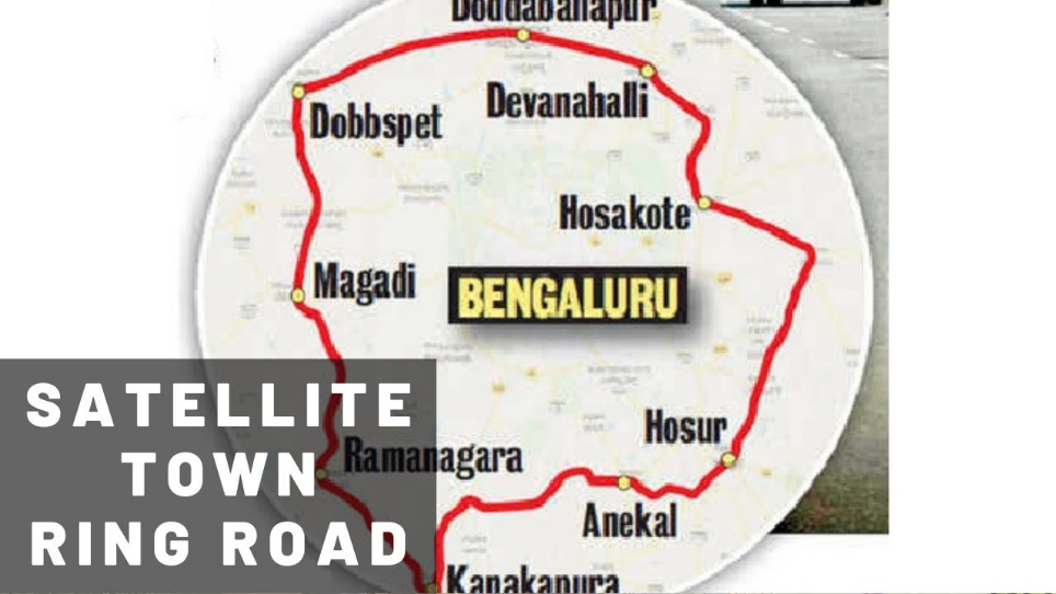
The Bengaluru STRR is a planned 288 km long corridor designed to connect 12 major satellite towns around Bengaluru. Unlike the city’s existing ring roads, STRR is much larger in scale and scope, extending into both Karnataka and Tamil Nadu. The road aims to divert heavy traffic away from Bengaluru city, especially vehicles passing through on long-haul journeys.
The length of 288 km is divided into multiple phases, ensuring that development progresses steadily while minimizing disruption. This makes the STRR one of the most ambitious ring road projects in India.
Which 12 satellite towns are connected by STRR around Bengaluru?

The STRR will link 12 prominent satellite towns, creating a development arc around the city. These include:
- Hoskote
- Devanahalli
- Doddaballapur
- Ramanagara
- Kanakapura
- Magadi
- Sarjapur
- Hosur (Tamil Nadu)
- Malur
- Anekal
- Nelamangala
- Dobbaspet
By connecting these towns, the STRR provides seamless road connectivity that reduces dependency on Bengaluru’s core roads while creating opportunities for balanced regional development.
What is the STRR completion timeline and current status in 2025?
As of 2025, STRR is being developed in phases. Phase 1, covering 82 km between Dobbspet and Ramanagara, has made significant progress, with several sections nearing completion. Land acquisition and environmental clearance processes are still ongoing for certain stretches.
The full completion timeline is projected around 2027–2028, depending on the resolution of land and environmental issues. However, the sections completed by 2025 are already showing benefits in terms of improved connectivity and reduced traffic bottlenecks.
How does STRR connect to national and state highways near Bengaluru?

The STRR has been strategically planned to integrate with multiple national and state highways. Some key connections include:
- NH-44 (Bengaluru–Hyderabad highway) near Devanahalli
- NH-75 (Bengaluru–Mangaluru highway) near Nelamangala
- NH-948 (Bengaluru–Kanakapura–Coimbatore highway) near Kanakapura
- NH-275 (Bengaluru–Mysuru highway) near Ramanagara
- SH-35, SH-82, and SH-87, linking interior towns and industrial belts
These linkages ensure smooth long-haul travel without entering Bengaluru city, significantly reducing transit time for commercial traffic.
Does STRR link to the Bengaluru–Chennai Expressway and Hosur?

Yes, the STRR is designed to connect with the under-construction Bengaluru–Chennai Expressway. This link near Hoskote and Malur will drastically improve connectivity between Bengaluru and Tamil Nadu’s industrial hubs.
The inclusion of Hosur, a fast-growing manufacturing hub, further strengthens the industrial and logistics appeal of STRR. This makes STRR not just a bypass but a strategic economic corridor.
What are the Phase 1 and Phase 2 sections of STRR with maps?
- Phase 1: Covers 82 km between Dobbspet, Devanahalli, and Ramanagara. This section is being prioritized due to its heavy traffic movement and proximity to Kempegowda International Airport.
- Phase 2: Extends to cover the remaining stretches, including Hosur, Kanakapura, Magadi, and Sarjapur. Land acquisition here is more complex due to cross-border sections into Tamil Nadu.
Together, both phases complete the 288 km stretch, enclosing Bengaluru in a broad economic arc.
Will STRR pass near Bannerghatta National Park and be elevated there?

Yes, the STRR alignment passes close to Bannerghatta National Park, a sensitive ecological zone. To minimize environmental impact, elevated corridors are planned in these stretches, reducing disturbance to wildlife.
This section has faced the most scrutiny and delays due to environmental clearances. However, the government has committed to balancing infrastructure with ecological protection.
How will STRR reduce congestion versus ORR/PRR and cut travel time?
The STRR is positioned farther out than the ORR and PRR, creating an outermost bypass for long-distance vehicles. This means trucks and interstate buses no longer need to pass through Bengaluru’s ORR, easing city congestion.
Travel time for cross-city routes like Hoskote to Ramanagara or Devanahalli to Hosur could be cut by nearly 40%, improving logistics efficiency. For residents, this translates into fewer traffic snarls on city roads.
Which growth corridors and hotspots will benefit most along STRR?
Several growth corridors are set to benefit from STRR, including:
- Hoskote: Already seeing plotted developments and logistics hubs.
- Devanahalli: Proximity to the airport makes it a magnet for real estate.
- Ramanagara and Kanakapura: Emerging as weekend getaway and second-home destinations.
- Hosur: Major industrial hotspot for automobile and electronics manufacturing.
- Sarjapur–Anekal belt: Gaining traction as IT-linked residential hubs.
How will STRR impact real estate prices in Hoskote, Devanahalli, Ramanagara, and Kanakapura?
- Hoskote: Prices are rising with warehousing demand and plotted layouts.
- Devanahalli: High growth expected due to airport, STRR, and ITIR plans.
- Ramanagara and Kanakapura: Affordable land values today could multiply as connectivity improves.
- Overall: STRR is likely to create a ripple effect similar to what ORR did in the early 2000s.
What is the expected speed limit and tolling on the STRR?

The STRR is being built to expressway standards, with a speed limit of 100 km/h on most stretches. Some sections may allow up to 120 km/h.
Tolling will be implemented to fund maintenance, with electronic toll collection expected for smoother movement. Rates are yet to be finalized but are projected to align with national expressway norms.
How much land acquisition is required for STRR in Karnataka and Tamil Nadu?
The STRR requires the acquisition of over 2,800 hectares across Karnataka and Tamil Nadu. Of this, a significant portion lies in rural stretches, while sensitive zones require elevated alignments.
Land acquisition has been one of the primary reasons for delays. Compensation disputes are being addressed through revised packages and direct farmer consultations.
What industrial and logistics hubs will STRR improve access to?
The STRR will provide better access to:
- Hosur industrial belt (automobiles, electronics, textiles)
- Devanahalli Aerospace SEZ
- Bidadi Industrial Area (manufacturing hub)
- Hoskote warehousing corridor
- Peenya Industrial Estate (via connected highways)
This improved access will boost Bengaluru’s positioning as a logistics hub for South India.
How to invest along STRR: plotted developments, villas, and warehousing?
Investors can consider multiple asset classes along STRR:
- Plotted developments: Ideal for long-term appreciation, especially near Hoskote and Kanakapura.
- Villas and gated communities: Demand rising in Devanahalli and Sarjapur belts.
- Warehousing and industrial sheds: Strong returns expected near Hosur and Hoskote due to logistics demand.
Early movers are likely to benefit the most as land prices are still comparatively affordable.
What are the environmental concerns and approvals for STRR?

Key environmental concerns include:
- Impact on Bannerghatta National Park and adjoining forests.
- Land use changes in agricultural zones.
- Noise and air pollution for towns along the alignment.
To address these, multiple clearances have been sought, with conditions for elevated stretches, noise barriers, and green belts. While delays are inevitable, approvals are being granted in phases.
Conclusion
The Bengaluru Satellite Town Ring Road (STRR) is not just an infrastructure project but a transformative corridor that will shape Bengaluru’s growth for decades. From easing congestion to unlocking new real estate opportunities, improving logistics, and connecting satellite towns seamlessly, STRR has the potential to redefine the region’s economic landscape.
For homebuyers and investors, STRR offers a rare chance to capitalize early on upcoming growth corridors. Plots, villas, and even industrial investments along this corridor are expected to appreciate as connectivity improves.
At Housiey, we bring you transparent insights into such projects to help you make better real estate decisions.
If this blog sparked your interest, make sure you also read our detailed take on the Metro Yellow Line — another project reshaping Bengaluru’s connectivity.
FAQs
- The STRR is 288 km long, covering both Karnataka and Tamil Nadu.
- It is one of India’s largest planned ring roads.
- STRR connects 12 towns including Hoskote, Devanahalli, Ramanagara, and Hosur.
- This ensures balanced growth beyond Bengaluru city limits.
- Full completion is expected by 2027–2028.
- Partial sections are already operational in 2025.
- It diverts long-haul traffic away from city roads.
- This reduces the load on ORR and PRR significantly.
- Yes, it links to NH-44, NH-75, NH-275, and NH-948.
- State highways also integrate seamlessly with the corridor.
- Yes, STRR connects near Hoskote and Malur.
- This enhances connectivity to Chennai and Hosur.
- Phase 1 spans 82 km between Dobbspet and Ramanagara.
- Phase 2 covers remaining stretches including Hosur and Kanakapura.
- Yes, but elevated stretches are planned.
- This reduces the environmental impact on wildlife.
- Vehicles can travel up to 100–120 km/h.
- Speed regulations may vary by stretch.
- Yes, tolling will be applied for maintenance.
- Electronic toll systems will be used.
- Over 2,800 hectares are being acquired.
- This includes land in both Karnataka and Tamil Nadu.
- Hosur, Bidadi, and Devanahalli are major beneficiaries.
- Logistics and warehousing will also see growth.
- Land values will rise near growth corridors like Hoskote and Kanakapura.
- Devanahalli is expected to see the highest demand.
- Hoskote, Devanahalli, and Hosur are prime choices.
- Ramanagara and Kanakapura offer affordable entry points.
- Plotted layouts and villas are ideal for individuals.
- Warehousing is lucrative for institutional investors.
- Concerns include forest clearance and biodiversity protection.
- Mitigation measures include elevated stretches and noise barriers.
- Yes, through Devanahalli’s stretch.
- This improves airport access from multiple towns.
- It reduces transit times for long-haul freight.
- This boosts operational efficiency and lowers costs.
- No, it is much larger and positioned farther out.
- It serves as the outermost bypass for Bengaluru.
- Early investments yield better returns.
- STRR will reshape growth corridors like ORR did in the 2000s.
L. Sadriwala, the Editor-in-Chief at Housiey, is a seasoned writer whose professional journey in content creation began in 2015. With a background rooted in a family of real estate developers, her transition into real estate writing was a natural evolution, bringing together her storytelling expertise and deep industry understanding.
Over the years, she has authored impactful blogs across diverse niches such as food, travel, and lifestyle, before establishing her reputation as a trusted voice in Indian real estate. Today, her work stands out for its clarity, accuracy, and ability to simplify complex property concepts for readers.
At Housiey, every article crafted by L. Sadriwala reflects thorough research, verified facts, and a reader-first approach. From decoding housing policies and trends to offering in-depth builder reviews and project insights, her mission is clear: to empower homebuyers and investors with the knowledge they need to make confident property decisions.
Her writing not only informs but also builds trust, making her one of the most credible editorial voices in the real estate space.
Related Stories